Ear Falls Spodumene Project
- Nearby existing infrastructure
- Ideal geological settings for LCT Pegmatite System
- Presence of spodumene-bearing and highly fractionated pegmatites
- Significant exploration potential
- Pervasive and extensive alteration halo
- Favourable mineralogy for pegmatites
- High degree of spodumene liberation
- Permitted for drilling, trenching, & geophysical survey
Summary
The Ear Falls Spodumene Project (20,623 ha) is located outside the town of Ear Falls, Ontario. Ear Falls has excellent infrastructure including highway and logging road access, power lines, services, and local labor. The spodumene-bearing pegmatites system was discovered in 2023, known as the Wenasaga Spodumene Zone, which at present has been traced for over one kilometer along strike. K/Rb vs Cs plot outlined eight highly fractionated targets that have the same fractionation intensity as the Wenasaga North Zone for follow up in upcoming programs. The well established geochemical and geological baseline and the accomplished biogeochemical survey will be able to explore for covered lithium mineralization along the 13 km long exploration corridor. The Ear Falls Spodumene Project is permitted for diamond drilling, stripping, and geophysical survey.
Exploration Highlights
- A brand-new spodumene-bearing pegmatite system discovered in the 2023 exploration season
- Up to 4.54% Li2O from grab sample
- Outlined a 13 kilometers long exploration trend based on geochemical sampling and geological mapping
- Testholes outlined extensive and pervasive alteration halo around spodumene pegmatites suggesting the presence of a larger system
- Established geochemical baseline of the lithium mineralization signature
- Effective biogeochemical survey for exploring buried lithium mineralization
- Permitted for diamond drilling, stripping, and geophysical survey

13 Km Exploration Corridor Structurally Controlled by The Granite-Sediment Contact and A Regional Fault
Latest News Releases
- January 26, 2024 – Beyond Lithium Intersects 2.30% Li2O over 3.84m in Wider Pegmatites Zone of 0.46% Li2O over 36.25m at the Ear Falls’s Wenasaga North Zone
- October 23, 2023 – Beyond Lithium Launches Stripping and Drilling Program at Ear Falls Project
- September 18, 2023 – Beyond Lithium Discovers New Spodumene Bearing Pegmatite Zone at Ear Falls Project in Northwest Ontario
Infrastructure
The Ear Falls Project (20,623 ha) is located near the town of Ear Falls (pop. 1,100) that is less than 10 minutes’ drive away from the southern property boundary. The Project is located 70 km south of Red Lake and 145 km north of Dryden with excellent infrastructure including a highway that connects the cities of Dryden, Red Lake, and Kenora, and logging roads access throughout most of the Project, power line along the main highway, local labor force, and equipment facility etc.
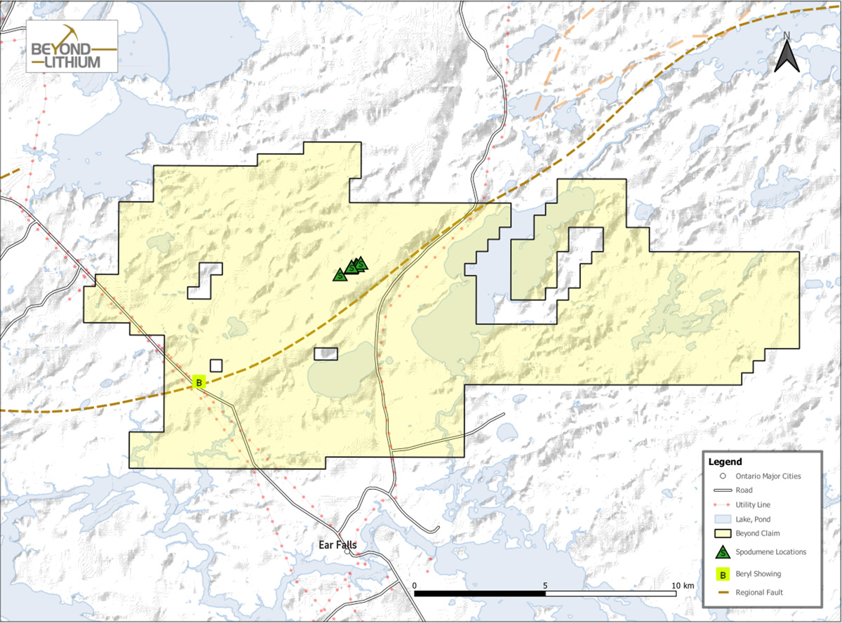
Ear Falls Project Claim and Location Map
Regional Geology
The Ear Falls Project is located in the English River Subprovince along a regional splay fault structure branched off from the subprovince boundary of the English River Subprovince and the Uchi Subprovince. The northwestern part of the Project is hosted in granite, the Wenasaga Lake Batholith, and the southeastern part of the Project is hosted in metasediment separated by the regional splay fault. The spodumene-bearing pegmatites and the lithium occurrence recorded by Ontario Geological Survey, the Sandy Creek Beryl, were discovered along the contact between the granite and the metasediment following the overall orientation of the regional splay fault.
Pegmatite Mineralogy
XRD (X-ray diffraction) study for modal mineralogy confirms the main mineralogy of the spodumene-bearing pegmatites are quartz, feldspar (albite, microcline), muscovite, and spodumene with accessory minerals (total <2%) include chlorite, beryl, fluorapatite, biotite; TIMA (Quantitative Evaluation of Materials by Scanning Electron Microscopy) study outlines >96% spodumene liberation.

Uncovering Spodumene-bearing Pegmatite

Channel Sampling of pegmatite and host rock
Exploration Upside
The Ear Falls Spodumene Project’s exploration corridor has a 13 km long strike length that has only been explored for 10% so far. This exploration corridor is well defined by geological mapping and geochemical profile based on lithium and cesium mineralization trends and fractionation intensity, K/Rb vs Cs ratio. In addition, the testhole program in 2023 successfully demonstrated the Project is a staked pegmatite system and outlined a pervasive and extensive lithium and cesium alteration halo in the wall rock indicating a potential larger system in the area. Furthermore, the southwestern Sandy Creek Beryl Zone has highly fractionated pegmatites measured up to 18-20 meters in width signifying the presence of wider pegmatites at the project. The biogeochemical survey trialed in the 2024 program has demonstrated its ability to detect buried lithium mineralization. In short, the Ear Falls Spodumene Project is fully equipped with the different exploration tools to further explore and to expand for additional lithium mineralization. Lastly, the Project is fully permitted for advanced exploration including diamond drilling, stripping, and geophysical survey.