Regional Geology
The Owl Creek Project is located within the regional Cascade Magmatic Arc that spans over 1,200 km from northern California to Canada (Hildreth 2007). The Cascade Magmatic Arc is a post-accretionary arc hosting several significant porphyry deposits for copper-moly and copper-gold mineralizations associated with Miocene intrusions including (Figure 1):
- Mt. Margaret in southwestern Washington State (Ascot Resources Ltd)8
- Historical geological resources of 523.0 MT at 0.36% Cu, 0.011% Mo, and 0.24gpt Au (CIM Special Volume 37, 1986)
- New Prosperity in south-central BC (Taseko Mines)7
- Total Measured and Indicated Resources at 0.15% Cu cutoff grade with 1,109 MT at 0.24% Cu and 0.007% Mo
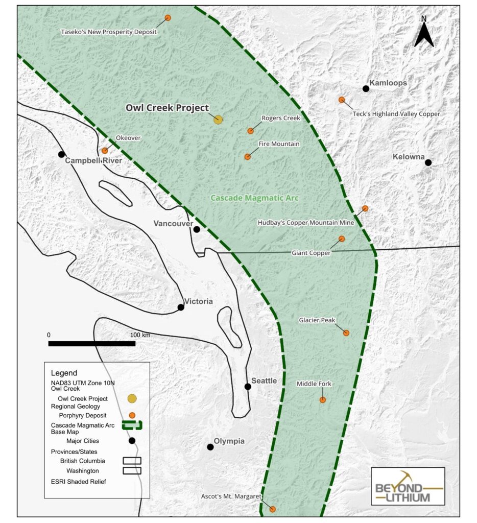
Figure 1. Owl Creek Project in Relation to Other Porphyry Projects in the Cascade Magmatic Arc
Historical Exploration Work & Highlights
- Early 1900s
- The Owl Creek showing was first discovered as early as 1913 referred as the Copper Queen prospect.
- 1960s to 1970s
- A 70 meters long adit was developed at the Copper Queen prospect, and an underground chip sampling program resulted 0.33% Cu over 66 meters from the adit (Rastad & Pezzot 2006).
- Pine Lake Mining completed diamond drillings, soil sampling, and magnetometer and induced polarization surveys (Naylor and Scott 1973)
- Diamond drill hole around the adit intersected 0.2% Cu over 182m
- Diamond drill hole in the northwestern area intersected 0.4% Cu over 91.4m
- 2010-2012
- Surface mapping, grab sampling, and airborne magnetometer survey based on Goldsmith 2011’s assessment report and Pezzot 2011’s geophysics report (Figure 2.)
- Grab samples from mapped diorite assayed up to 1.99% Cu
- Magnetometer survey outlined the NW striking trend and delineated several anomalies in relation to the magnetic signature of mapped mineralized diorite
- Surface mapping, grab sampling, and airborne magnetometer survey based on Goldsmith 2011’s assessment report and Pezzot 2011’s geophysics report (Figure 2.)
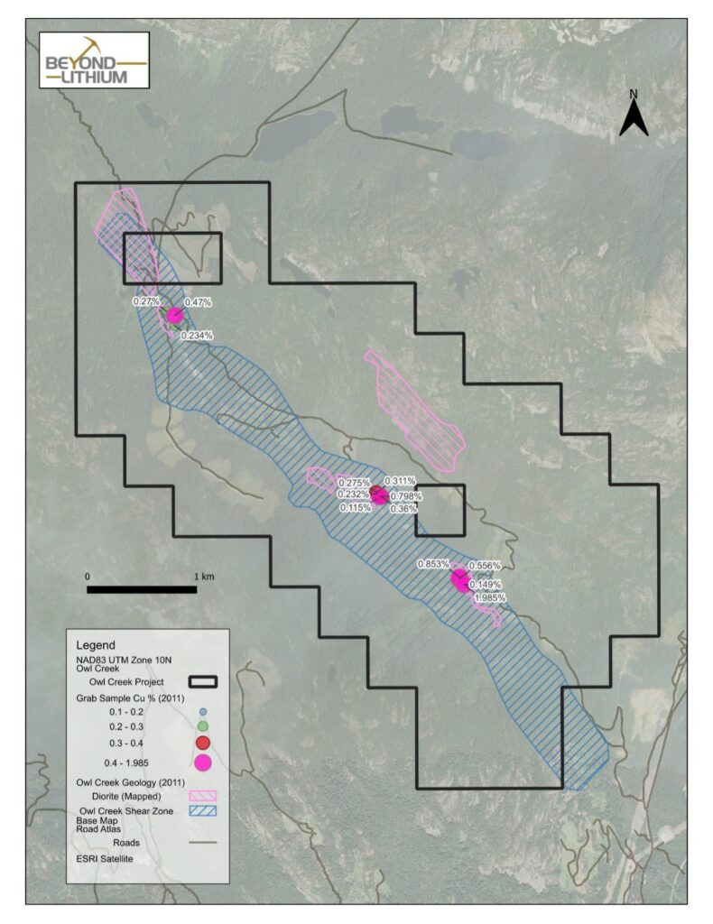
Figure 2. Owl Creek Property Map with Surface Grab Samples and Mapped Diorites and the Main Shear Zone from 2011 assessment report #32271 (Goldsmith 2011)
B.C. Mineral Claims Consultation Framework
In March 2025, the Province of British Columbia introduced the Mineral Claim Consultation Framework in response to a BC Supreme Court ruling, which affirmed the government’s duty to consult Indigenous communities prior to registering any mineral claims. Beyond has submitted a mineral claim application for the Owl Creek Project and it is anticipated that the consultation process will be underway by early September 2025.
- Goldsmith, Locke B. 2011. Owl Creek Mineral Claims Geological, Rock Geochemical, and Airborne Magnetic Surveys Report. Geological Survey Branch Assessment Report #32271.
- Hildreth, Wes, 2007. Quaternary Magmatism in the Cascades – Geologic Perspectives. https://pubs.usgs.gov/pp/pp1744/
- Naylor, H. and Scott, J.S. 1973. Pine Lake Mining Co. Ltd., Geological Report, Owl Creek BC Geological Survey Branch Assessment Report #04623.
- Pezzot E. Trent. 2011. Geophysical Interpretation Report on an Airborne Magnetometer Survey. Clear Mountain Resource Corp. Geological Survey Branch Assessment Report #32271.
- Rastad, S., and Pezzot, E. T., 2006. 3D induced polarization on the Gold King Property, Tenquille Lake grid, Pemberton, BC, Goldking Mining Ltd. Geological Survey Branch Assessment Report #28607.
- BC Government Mineral Exploration and Mining. May, 2025. https://www2.gov.bc.ca/gov/content/industry/mineral-exploration-mining/mineral-claims-consultation-framework
- https://www.tasekomines.com/properties/new-prosperity/reserves-and-resources
- https://ascotgold.com/projects/non-gold-assets/mt-margaret/